Geographic Information Systems (GIS)
 GIS is a System of computer software, hardware and data, and personnel to help manipulate, analyze and present information that is tied to a spatial location:
- Spatial location – usually a geographic location.
- Information – visualization of analysis of data.
- System – linking software, hardware, data.
- Personnel – a thinking explorer who is key to the power of GIS.
GIS Applications
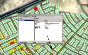
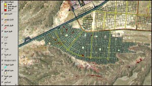
- Geo Database.
- Digital image maps.
- Hard copy maps.
- 3D Elevation Model.
- Scientific investigations.
- Resource management.
- Asset management.
- Archaeology.
- Environmental impact.
- Assessment.
- Urban planning.
- Cartography.
- Geographic history.
- Marketing.
- Logistics.
- Prospectively mapping.
Services Provided
The services we provide fall generally into following main categories:
- Geo Database Building.
- Data Services.
- GPS data collection.
- Vectorization from hard copy maps and Satellite Images.
- Data Conversion and Migration.
- 3D Maps and Fly Simulation.